In June 2022, Matt undertook a Maritime Archaeology Course run by the Nautical Archaeology Society. This involved how to record and survey underwater archaeological sites. Matt tells us about his experience.
As much as I completed my practical training in June this year, my course actually started in the first Covid lockdown of 2020. I had known about the Nautical Archaeology Society for a number of years and knew that they did some kind of underwater archaeology course but never found the time to look into it. Like so many of us during the lockdowns, I used my free time to look into it further.
The archaeology course was split into two parts; theory and practical courses. The theory had two online courses, the first explained what archaeology is, some basic terms and definitions and why archaeology is important. It also explained the difference between archaeology and history (history is written evidence, archaeology is physical evidence). The second online course showed how archaeology was applied underwater. Both courses combined took 8 to 10 hours in total. It’s set up that you do it in your own time and there’s no ‘expiry time’ on the videos.
Covid difficulties and work commitments meant it was two years before I was able to attend the practical course. It was held at a place called Vobster Quay which is a diving lake in Somerset (they do run courses closer) and while I won’t go into the full list of pre-requisites, you have to be a competent SCUBA diver already to do the course. My tutors were two members of the NAS who had extensive experience of working on underwater sites all over the world. The practical course lasted two days and involved 3 dives onto a fake archaeology site in the lake situated at 12 metres (40ft) depth. The course also featured dry practicals as well.
The faked site was interesting, as it was newly set up and we were the first people to use it. It consisted of a submerged jetty, a small boat (something between a dinghy and a canoe), a small anchor mounted on a pallet, and some ‘artefacts’ cemented onto other pallets scattered to the other side of the jetty which included a tankard, a hook and some drinking mugs.
The first dive was a photography dive. We were instructed to go to the site and take photos. They wanted us to take some overall photos or site photos as best as we could (underwater visibility wouldn’t allow a full plan in one shot) and then try to take some close ups of the artefacts or other points of interest. We were encouraged to make sure we had scale cards and north arrows to show the orientation and size of the site. We had a practise run ashore with some cut-outs depicting a wooden wreck next to the classroom before venturing into the water.
The site was quite small, measuring approximately 8 metres by 6 metres (27ft by 20ft), which made things a bit congested with five divers. Because of this the silty bottom got disturbed clouding the visibility. The overall site photos proved a challenge, but we got some good close-ups. I focussed on sections of the boat and the jetty, particularly the corners to show how sections were joined. On a real site, identifying the engineering methods employed (eg, rope, nails, etc) could help date the site.
After a quick break, we were back in for the second dive. This time, our objective was to sketch the site. Similar practise again, we needed a site plan and then some sketches of particular artefacts or features. Given that I have the artistic ability of an eight year old, this would be challenging when coupled with doing this underwater!
Going back to the site, I was relieved to find that although the silt was kicked up easily, it was fairly dense and so had more or less settled by the time we got back. In some ways the site plan was easier to sketch than photograph as we could piece it together section by section. I found a cement block which featured a tankard and a couple of other ‘artefacts’ and settled down to sketch them. I also included a few measurements.
That was the diving done for the day and that afternoon we finished off with a lecture about how to deal with artefact finds and how to raise them should it be necessary. It was very informative, and I wish to point out that the course did not give me any more rights to lift artefacts than anyone else. The lecture was more like a code-of-practise. We were told that by leaving an artefact in place we can learn more about it. It’s position on the wreck may determine who owned the find originally, or what purpose it may have had. The sediments may also give a date as to how old the artefact is, or how the wreck has deteriorated. We were shown how an artefact should only be recovered if it is in danger of being destroyed or lost forever, and even then before it is raised to ensure we have a plan on what to do with it. First of all, there are numerous bits of legislation protecting artefacts, so we would need to check what licenses would be required to recover it. Will conservation techniques work? Can the artefact be stored somewhere while preservation gets underway? Once the artefact has been restored, can it be displayed somewhere? And of course, are funds available for the restoration? To put things in perspective, conserving a single cannon ball usually costs around £100. On the other end of the scale, the entire Mary Rose recovery, preservation and museum has cost to date an eye-watering £35 million!
The second day was more technical and involved learning survey techniques. The survey techniques are aimed to be able to pinpoint where features are on a site. The simplest type is the offset survey. This involved running a tape (called a baseline) between two control points and then measuring where certain artefacts were along the tape and also how far from the tape they were (eg, a clay pipe can be 1.5m/5ft along the baseline and then 0.9m/3ft away from it). We practised these on a similar dry-site in the dive site car park. We were encouraged to focus on getting a few good marks rather then lots of suspect measurements.
We entered the water in slightly staggered pairs. I was in the last pair and remember swimming towards the site and seeing a big cloud in front of me! The task for me and my dive buddy was to get the measurements of the bow and stern of the boat. This proved a challenge as we all needed to be working on the same baseline (in reality there would be numerous control points and baselines on a site). I was ducking and diving between other divers. The visibility, to put it mildly, could have been better. At one point I had my face just a few inches from the tape measure and my underwater writing slate. My dive buddy and I swam away from the site into clearer water whilst we came up with a plan to how best get other measurements using a combination of writing on the slate and some muffled/illegible speaking through a breathing regulator. With the plan set we swam back into the cloud, and for an embarrassing couple of minutes couldn’t find the site. Eventually I found it after all but swimming into the boat.
After the dive we surfaced and compared the marks, drawing them onto the paper. Somehow one of my marks was completely out, but it goes to show how much harder things are underwater.
The course proved why they held the pre-requisites for the diving. Whilst you didn’t have to be an overly experienced or highly qualified diver to do it, the diving does have to be second nature to you. When you’re swimming around in challenging visibility running tapes and drawing sketches there’s enough to keep you occupied without thinking about how to dive.
The upshot was that we all passed the course and gained a Foundation in Maritime Archaeology. I really enjoyed the course and learnt a lot from it. I met some really interesting people, both students and instructors, and I dived a site I hadn’t been to before which is always a joy.
So, what now? I should add that the Nautical Archaeology Society is predominantly run by volunteers and this course is very unlikely to land me a paid position (not without appropriate academic background at least), but I never took the course with the intention of changing career. Theoretically, there’s nothing stopping me running my own archaeology project. All that’s stopping me is confidence and experience. With that in mind, I wish to use my course to get onto archaeology sites around the country to help out with their surveys and research. Underwater sites the NAS work on include the HMS Invincible which sank in 1744 and the HMS Colossus which sank in 1798. But their sites aren’t just constrained to being underwater, they also study sites in intertidal areas and even inland so there are plenty of opportunities for non-divers to get involved. There is a similar course to the one I did which focusses on terrestrial and intertidal archaeology sites and you don’t need to be a diver to do them.
I would like to think that I will do some small-scale studies on local wrecks off the Yorkshire coast. I’m very aware that most of the wrecks are First World War merchant ships and they are decaying. Even in the twelve years I’ve been diving I have seen parts of wrecks collapse and become more unstable. It is impossible to conserve every single wreck off the coast, the elements will always win. So it’s important to record how they are so they can be studied in years to come. Whatever projects or plans I come up with, I’ll be sure to keep Scarborough Maritime Heritage Centre involved.
To find out more information about the Nautical Archaeology Society, please visit www.nauticalarchaeologysociety.org
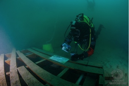
Photo above: Matt and his camera at the end of the submerged jetty on the first dive. You can see the yellow control point on his right with a rope leading to a buoy on the surface. In his left hand you can see a scale card which also has a ‘North’ arrow on it. Credit: M. Blatchford.
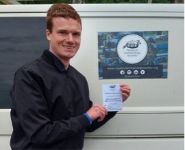
Matt Newsome: Qualified in Underwater Archaeology. Credit: I. Cundy